
OVERTON — Ever wanted to get a sense of what Jonah experienced when he was swallowed by the whale?
Standing in front of an oncoming shelf cloud and attendant squall line is a fairly close approximation. This was what I got to experience on Sunday, June 2 outside of Overton.
Most of central Nebraska was under a wind driven Enhanced Risk for severe weather during the early evening hours on Sunday. Thunderstorms were set to develop across the Panhandle and grow upscale into a large line or mesoscale convective system (MCS).
An MCS is a complex of thunderstorms and their overall cloud and precipitation pattern may be round or linear in shape. These types of systems usually tend to form near weather fronts, often a cold front.
The time period in the Plains where thunderstorm areas are most prevalent ranges between May and September. MCS’s develop over the region during this time frame, with a bulk of the activity occurring between 6 and 9 p.m. local time.
MCS’s bring 30 to 70 percent of the annual warm season rainfall to the Plains.
Particularly strong straight-line winds can occur where the linear structure forms into the shape of a bow echo.
That is exactly what was forecast to roll through central Nebraska Sunday evening.
I had been keeping an eye on the radar waiting to see if any discrete development would take place in southwestern Nebraska. As it would play out, there would be no storm formation whatsoever.
However, thunderstorms had developed in the Nebraska Panhandle and were slowly progressing to the east. It was apparent that a linear structure was forming and that an MCS would be the storm mode.
I waited for the storm’s to press into the local area, when a tornado warning had been issued for western Dawson County. To my knowledge, no tornado would occur, which was good news for my former co-workers who I was in contact with and sharing information about the thunderstorm.
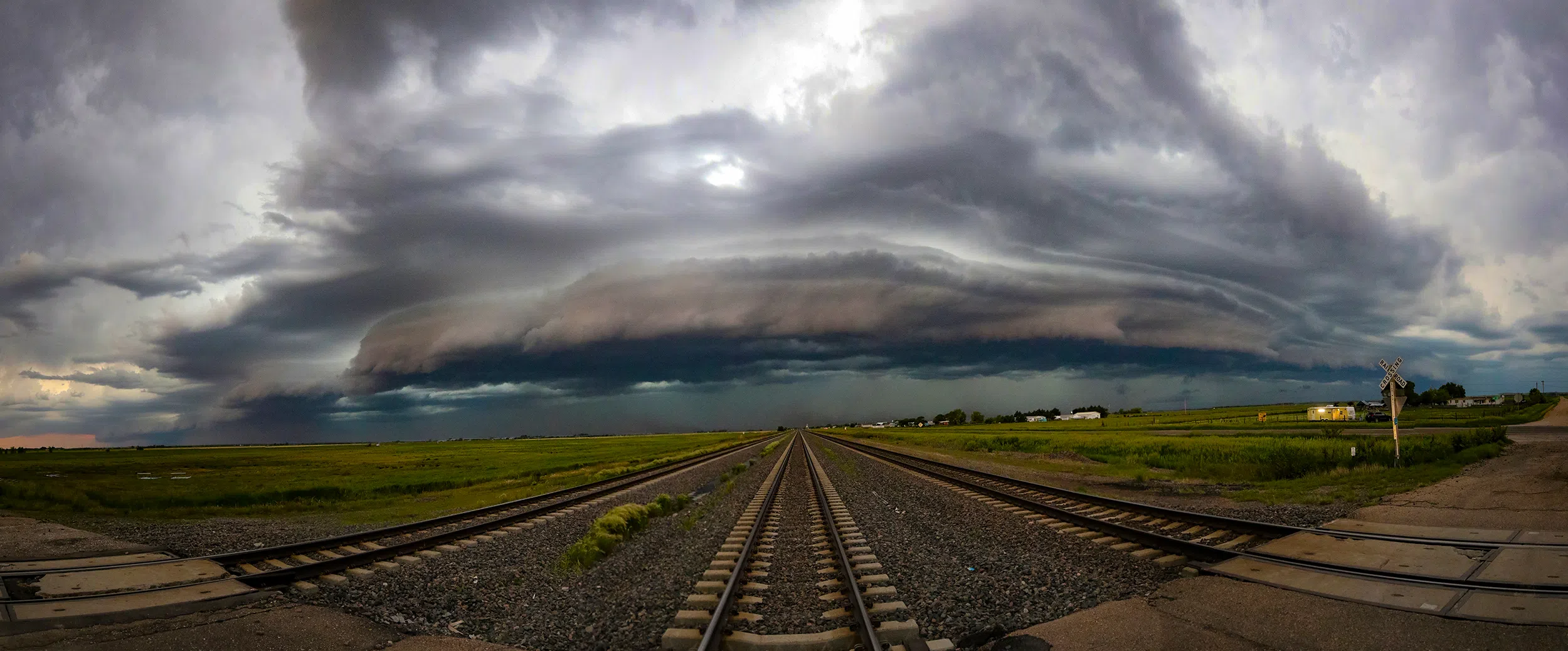
I could see the distant shelf cloud structure as I headed west down Highway 30 and eventually drove through Overton and stopped just south of the railroad tracks. I pointed the car and cameras to the west and let the system approach.
This wasn’t the first MCS I have documented, but they never fail to impress. A supercell might be a localized engine of severe weather, but a MCS can extend for hundreds of miles, making staying out of its way all but impossible.
Storm spotters and chasers have a unique name for the edge of a shelf cloud, the Whale’s Mouth. The feeling of the edge of the storm complex overtaking you does feel like you are being swallowed by some gigantic creature.
While I was watching the shelf cloud approach, I noted several lightning strikes and these weren’t any ordinary cloud-to-ground strikes.
Negative cloud-to-ground (CG) strikes are far more common and can be distinguished by their various branches and visually appear to flicker along the channel.
Positive CG lightning makes up less than five percent of all strikes. However,despite a significantly lower rate of occurrence, positive lightning is particularly dangerous.
These strikes can be visually distinguished by their lack of branches, bright flash and visually the branch seems to dissolve after the strike.
The strongest positive CGs are roughly ten times stronger than the average negative CGs. Positive CGs can reach temperatures of 54,000 degrees, around five times hotter than the surface of the Sun.
For the laymen the difference is relatively simple. If directly struck, a negative CG could kill you, a positive CG will kill you.
I witnessed several positive CG strikes on the leading edge of the shelf cloud and I knew I had to give the edge of the storm a wide berth.
The closer the edge of the shelf cloud came to my position, the more dust I could see being lifted up into the air, a clear indication of the gust front. My general rule is that when the gust front hits my location, it’s time to move.
I took my last series of photos that I would combine into a panoramic later when I looked to my south and saw a large area of dust violently moving east and crossed the road. That was all the encouragement I needed to get the car in gear and head east.
The light was starting to fade as I passed through Elm Creek, my plan was to stop one more time to get a few final shots before I sought shelter at home.
After some back and forth on where I should stop, I was able to get a few photos of the edge of the shelf cloud to the north. However, the storm was so close to the west that I couldn’t fit all of the cloud structure in my camera lens.
As I passed through Odessa, I felt I had a couple minutes and drove north of town for a few final shots of the clouds to the north. I often look for foregrounds with leading lines and in this case Odessa Road was a good fit.
With the edge of the wall of precipitation bearing down on town, I decided I was out of time and drove back home and got inside just ahead of the worst of the wind and rain.
Being a property owner has now made me quite wary when severe storms impact the local area. I did my usual routine of pacing around the house, looking out different windows while having one eye glued to the radar.
Luckily, the wind was strong but not enough to cause damage. However, I saw photos later of larger trees and limbs blown down in Shelton and St. Paul.
If I have learned anything about storm chasing, it’s that supercells and tornadoes may get all of the press, but I never underestimate the threat of straight line winds from linear systems.
I just hope the whale continues to spit me out each time I get swallowed.