
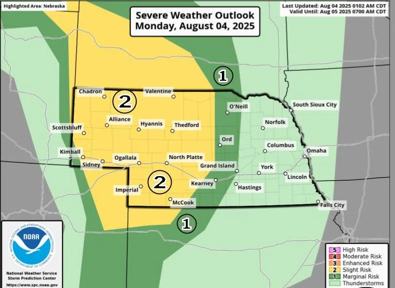
A conditional threat for severe weather exists for western and parts of central Nebraska, (NWS North Platte, Courtesy)
KEARNEY — There is a Slight Risk for severe weather that just clips the edge of central Nebraska for the evening of Monday, Aug. 4.
According to the National Weather Service – North Platte, the Slight Risk, a two out of five, mainly rests over western Nebraska, but the risk does impinge upon Dawson County.
NWS North Platte states that the threat for severe weather is “highly conditional” today and there is uncertainty in terms of the severe weather potential, but the conditions will be in place to support strong to severe storms.
A low-pressure system is expected to develop over Wyoming and low-level flow will increase across the High Plains and result in strengthening southerly flow, which will promote warming temperatures and modest transport of moisture to the region.
Dewpoints are expected to climb into the upper 60s and high temperatures are expected to be in the upper 70s in central Nebraska.
Inhibition does not appear to fully erode and with the lack of greater forcing, storm coverage this evening is expected to be limited. Storms that form will be able to tap into strong instability and deep layer wind shear.
Any storms that form will be more discrete in the early afternoon and pose a threat of large hail and strong winds, an isolated tornado cannot be fully ruled out. As the evening progresses, storms should merge into a cluster and progress east or southeast.
How much central Nebraska will be impacted depends on the storm coverage and the direction a storm complex will take if it is able to form.