KEARNEY — Central Nebraska is once again under the gun for severe weather, with the primary threats of severe winds and large hail occurring from 10 p.m. to 3 a.m.
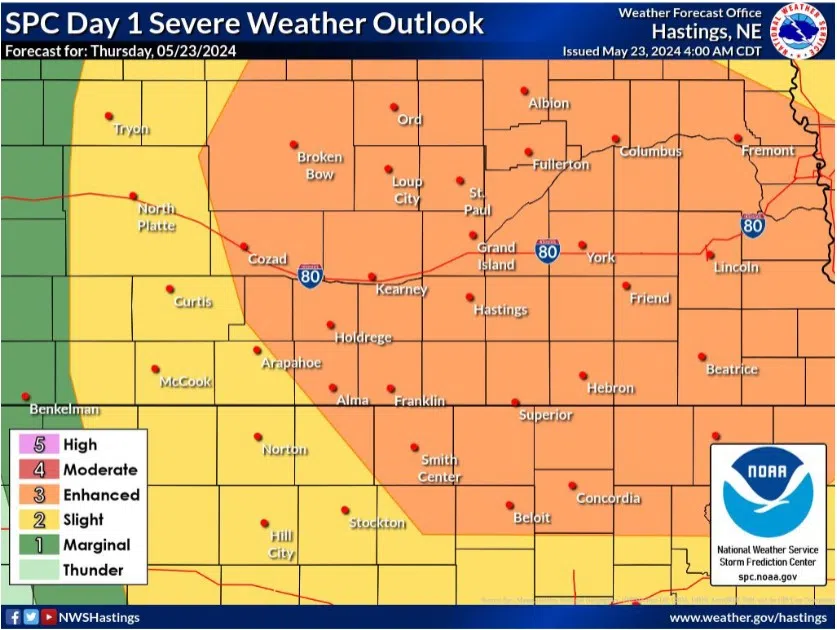
The Storm Prediction Center in Norman, Okla. has issued an Enhanced Risk, a three out of five, across central into eastern Nebraska. The main driver of the risk is the likelihood of severe winds up to 75 mph.
The National Weather Service – Hastings states that most of the area around the Tri-Cities should be dry today at least through 8 p.m.
There is a slight chance of isolated thunderstorm development within the warm sector ahead of a cold front that will be entering the area this evening. Any isolated development will happen out west and if isolated supercells form, they could pose an all-hazards threat.
However, a strong cap could suppress thunderstorms entirely until a line of storms tracks from west to east across the forecast area with the cold front between 10 p.m. to 3 a.m.
Strong to severe thunderstorms are likely across the area this evening. A squall line with bowing line segments is the main forecast concern this evening.
The primary severe weather threat during the late-night hours with this Quasi Linear Convective System (QLCS) will be severe winds including the potential for a few high-end severe wind reports of over 75 mph. The larger golf ball hail threat will primarily be with any isolated storms that can form earlier or during the earlier portion of the line’s development,” NWS Hastings stated.
There is a chance for rain wrapped QLCS tornadoes embedded within bowing line segments late this evening as the low-level shear begins to increase.
Have multiple ways to receive warnings this evening and be prepared to take shelter if necessary.


