
AKRON, Colo. — It’s hard to describe to the laymen why I would be willing to travel 10 hours in total to the High Plains of Colorado on a work night. I was looking for tornadoes, but what I witnessed still commanded my respect.
There had been a lull in severe weather chances following the fury that occurred in late April and early May. It had been a welcomed downtime, but the itch to chase during the peak season always catches back up.
I had my eyes initially on Sunday, May 19 for a threat of tornadoes in west central Oklahoma, but eventually decided the 14 hours of travel time alone before the Monday workday wasn’t worth it.
Ironically I would only trade in four hours after my chase on Monday night.
My attention then shifted to Monday, a shortwave trough was set to eject over the Rockies and winds over the High Plains of northeastern Colorado were set to be out of the west. We had an upslope flow chase on hand.
Upslope flow describes air that flows toward higher terrain, and hence is forced to rise. The added lift often results in widespread low cloudiness and stratiform precipitation if the air is stable, or an increased chance of thunderstorm development if the air is unstable.
When it comes to forecasting severe weather, the dew point temperature is a key in forecasting. I often look for dew points of 55 or higher when chasing in the central Plains.
But due to the higher terrain of the High Plains, the surface pressure drops the higher you go. So a dew point of 50 or high 40s can get the job done in Colorado when it comes to severe weather.
That is what I was counting on during the evening of Monday, May 20.
Upslope flow was set to begin over Colorado during the day and this would lead to the development of storms that would move into an environment conducive for supercells, responsible for producing the majority of tornadoes.
The better moisture seemed to be set to arrive in the area just in time, with 50s dew points nosing into northeast Colorado.
Models seemed to hint at storms forming near the Denver metro and then tracking to the northeast before fully maturing and tracking east, eventually into southwest Nebraska.
The only hitch I noticed was that storms would form much later in the day and there might only be an hour or two of daylight to observe these storms.
I tend to call any chase once darkness sets in – driving in unfamiliar territory at night can be dangerous enough without throwing in a damaging storm.
Still, I was anxious to have another chasing opportunity and on my last trip to the High Plains, it had yielded me five tornadoes in one evening in Wyoming and extreme western Nebraska.
The area has its own charm; I am always put in mind of a Western movie looking at the acres of sagebrush and barbed wire fences. Seems like it would be more appropriate to storm chase on horseback in the region.
I had been monitoring the satellite view all day, looking along the lee of the Rocky Mountains, clouds were percolating all afternoon and I didn’t want to have to leave work until it was absolutely necessary.
Storms that occur in upslope flow seem to need time to grow into supercells as they push off the higher terrain, so I felt reasonably confident I could make the three to four drive and let storms mature.
By 3:30 p.m., the first radar echoes of storms beginning to fire was my signal to begin the trek down west. The initial storms seemed to struggle in the drier air but the kept persistently trying to initiate as I hit I-76.
I paused in Julesburg, Colo., to assess the situation. For once this chase season, everything seemed to be in place. The storms were set to track northeast into an unstable environment with enough wind shear for supercells to organize.
My only worry was jumping the gun, picking the wrong storm to follow and being out of position when the real storm of the day revealed itself.
It became apparent that I was going to have to move further west and eventually set my target for Sterling, Colo. A set of about three individual cells were moving to the northeast and the southernmost storm was starting to show supercell characteristics.
As the southern storm began to mature, it’s direction began to shift from northeast steadily to purly east. Unless I wanted to tangle with its rapidly strengthening forward flank and hail, I had to bail south to Akron, Colo., – and fast.
The supercell structure was plainly in view as I headed south. The visibility over the open plains is amazing, I swear you could see a tornado from 30 miles away if it came to that.
Things were tense during the 30 minute blast south, I was hoping I could get south of what was clearly a strengthening supercell. Tumbleweeds were being blown across the road, toward the storm, a sure sign it was strengthening.
Another sign that this storm was growing was the immense tail cloud that seemed to reach across the entire southern horizon. As though fuel was being poured into an engine, moisture was being fed directly to the storm
Just north of Akron, I spotted the mobile Doppler on Wheels scanning the storm as it approached. I knew that if this research unit was here, I had picked the right storm.
I drove south of Akron to get a better view of the supercell, the area was already beginning to fill up with other chasers who all had the same idea.
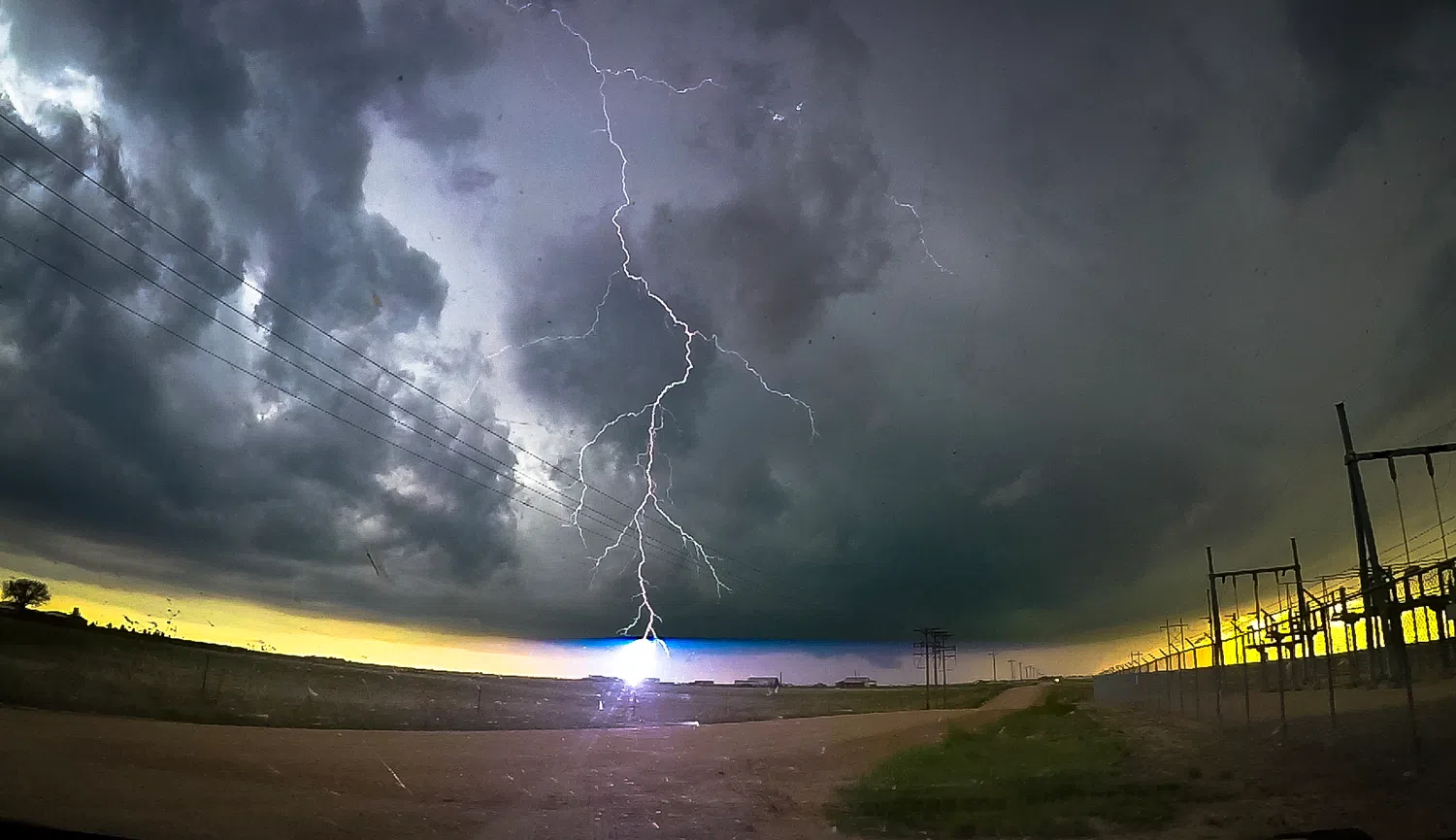
What surprised me when I stopped was the amount of lightning happening out ahead of the storm. I decided to stay in the car as bolts arched through the air or struck the ground around the community.
The thunder I heard was a distinct crackle followed by a deep boom, this storm clearly meant business.
A wall cloud began to form and I kept my eyes on it as any tornado would occur near this feature. However, it only lasted a short time before it vanished, but I had hoped the storm would cycle again.
There had been some dusty circulation near the rear flank of the storm, but I discounted this a gustnado, a small, short-lived whirlwind that forms within a thunderstorm’s gust front.
I moved south to give the storm’s rear flank some more room and was treated to the sight of a dark storm, shaded by blues and greens, back lit by the orange of a setting sun.
As I watched the supercell continue to push east, I became clear it was taking on high precipitation characteristics.
High precipitation, “HP” supercells occur in environments with rich low-level moisture and moderate-to-strong wind shear, and are a threat for tornadoes, large hail, damaging winds, and flash flooding.
From a storm spotting perspective, I look at a supercell’s rear flank area to get a sense of how a storm is developing and what stage it is at. In an HP supercell, this entire area is shrouded in rain.
As I let the storm approach, the view seemed to be that of a waterfall but over the Plains. A look at the radar indicated that this cell was going to be a prolific hail producer.
I also ran into an issue that I typically try to avoid but given the area sometimes it cannot be helped. Normally I try to stay on paved roads, as gravel roads can be in a questionable state of maintenance at best, or a soupy mess at worst.
However, in rural Colorado, paved roads are few and far between and if you want to have any hope of staying with a storm, you have to use the gravel roads. Luckily the road I found was in good shape, my compliments to the Wash and Yuma county road departments.
Light was starting to fade rapidly but I didn’t want to abandon the storm just yet if it still had tornado producing ability.
Looking at a new rear flank surge in the twilight next to chasers from Oklahoma, I saw what I thought could be a funnel but it was clear after a moment it was just scud or a “Scary Looking Cloud,” as chasers call this tornado look-alike.
I paused one last time just after 8 p.m. MDT to get a look at the storm, but by this point, darkness had truly set in and the features of the storm were only illuminated by the near constant lightning.
With my cameras struggling to focus in the dark, I decided to call the chase and began trying to outpace it while I headed to the east.
It was by this point that the HP supercell had begun to go into hail production overdrive. Tennis ball sized hail was warned for near Otis, Colo., and it would eventually dump nearly a foot of hailstones in Yuma, the pictures were reminiscent of a snowdrift.
I had to keep to the gravel road that was running parallel to Highway 34, I couldn’t turn north without running into the storm and that was a guaranteed way to lose a windshield or worse.
Finally, I made it to the pavement and headed up to Wray to join the highway that would take me back to Nebraska.
The constant lightning reminded me the storm was right behind me. I had a distinct sense of feeling guilty that I could simply drive out of harm’s way, while people’s homes and property could easily be damaged by the oncoming storm.
Still, I had my own home to return to, central Nebraska was under the gun for severe weather itself the same night.
I finally stopped at McCook to fuel up for the rest of the way home. While doing so, other chasers were pulling in to do the same. I struck up a conversation with the man across from me and we both agreed we saw some amazing storm structure but nothing tornadic.
To my surprise, he said he and his partners would be driving onto Lincoln that night to be in position to chase the next day in Iowa, where a moderate risk for severe weather existed.
Given that I was set to arrive at home after 1 a.m. and needed to work the next day, I wished them luck in their subsequent chase.
The storms behind me had started to join into a large complex and the danger for straight line winds was increasing. While I was out of harm’s way, my drive down Highway 34 seemed to signal yet another community that was under the gun.
I would later learn that wind gusts reaching 93 mph had been recorded in Dundy County and did indeed cause damage, including trees blown down and power lines damaged.
The rest of the drive home was uneventful, something I was thankful for. I’ve had to punch through thunderstorm cores after dark and the experience leaves the nerves shattered.
I finally made it home at 1:30 a.m. and practically fell into the house.
I knew there was the oncoming squall line to worry about and that it would impact western Buffalo County around 3 a.m. But I was too worn out and thought that if it was bad enough, the storm would wake me up.
Reflecting on Monday night, while the setup yielded no tornadoes that I was able to witness, I was still able to maneuver close to the most prolific hail producing supercell I have seen to date.
This chase was a reminder of why I enjoy chasing in the High Plains, it’s a unique territory that is differs from the central and southern Plains but the storms can be just as awe inspiring.
Editor’s Note: My name is Brian Neben and this is my sixth year as storm spotter and chaser. I write a personal column about each outing, as it helps to collect my thoughts and I have felt like people enjoy reading about my success or failures perusing this rather niche hobby.